

The Gallery of Geographical Maps
Artist: Ignacio Danti
Date: 1580 - 1583
Classification: Painting on a wall
Dimensions: 120 m
Materials: Painting on a wall in secco and fresco
Adopted By: The California Chapter
Total Cost: € 1,892,000
Description
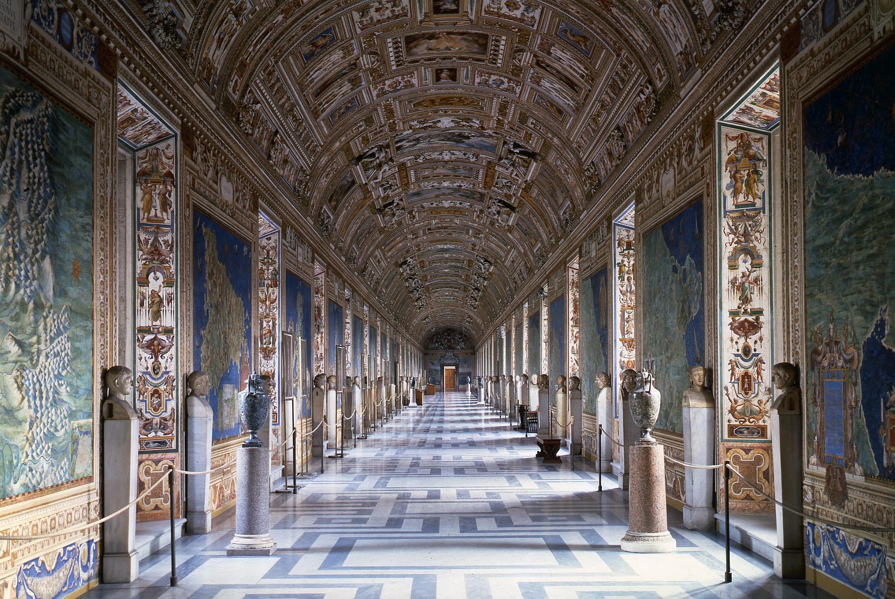
The Gallery of Maps is located in the corridor flanking the west side of the Belvedere Courtyard and was commissioned in 1580 by Pope Gregory XIII (1572-1585) as part of other artistic works commissioned by the Pope to decorate the Vatican. A series of 40 panels are filled with the topographical maps of Italy based on drawings by Dominican friar and geographer, Ignazio Danti, famed for having the most accurate maps of his time. They represent the Italian regions and papal properties at the time of Pope Gregory XIII. It took Danti three years (1580–1583) to complete the sections of the 120-meter long gallery. These frescoes constitute the largest cycle of geographical images in Europe. The panels map the entirety of the Italian peninsula in large-scale frescoes, each depicting a region as well as a perspective view of its most prominent city. With the Apennines as a partition, one side depicts the regions surrounded by the Ligurian and Tyrrhenian Seas, while the other depicts the regions surrounded by the Adriatic Sea. The maps are more like bird's-eye views with sailing ships, soldiers' tents, medieval battlements, and cypress trees dotting the hillsides. An anonymous poet, celebrating the gallery's opening, wrote:
"Each region is placed under its ruling planet and occupies an entire panel which shows the cities, castles, and villages with their streets and houses huddled together. Neither are the rivers forgotten, nor the springs, steep valleys and gentle hills, the green shade of the woods, the windswept shores, and the green expanses of the sea that truly seem to move...."
Danti, an astronomer, cosmographer, and mathematician, moved from Bologna to Rome to prepare the cartoons for the maps, in a conscious imitation of the ancient Roman custom of decorating the walls of state buildings with geographical images. With its white-capped waves, meandering streams, sailing ships, and limpid sunrises, the Gallery of the Maps is one of the most well-known in the Vatican Museums. The window cases are also richly decorated in the grotesque style made famous once again by Pinturrichio in the Borgia Apartments. There are 36 decorated window jambs, or strombi, which will also be restored along with the 40 maps.
- Venetiae Civitatis and Genua - Roberta and Howard Ahmanson
- Civitas Vetus - Bruce L. Ludwig Family
- Ancona and Melita obsidione liberatur and Classis Turcarum ad Crocyleium profligata - Dan Murphy Foundation Italia Nova - Maude and Richard Ferry in honor of John D. Ferry (Sforza)
- Italia Antiqua - Janet and Michael Fourtiq
- Liguria - Marcia Wilson Hobbs in Honor of Amb. and Mrs. Wilson
- Pedemontium and Monferratus - Eileen Dibb-Haub and Robert Haub in memory of Bernard Dibb and Leora Haub
- Mediolanensis Ducatus - Virginia Milner
- Persinus ac Tifernas - McLoon Family and Knott Family
- Transpadana Venetorum Ditio - Steph and Tim Bush
- Patrimonium Sancti Petri - Roberta and Howard Ahmanson
- Umbria - Randalyn and Gregory Stanislawski
- Placentiae et Parmae Ducatus - Chris and Joe Popolo Family
- Latium et Sabina - The Turicchi Family Foundation
- Mantuae Ducatus - Therese and William Wolf
- Campania - Janet and Michael Scott Feeley
- Ferrariae Ducatus - Cynthia and Christoph Tribull
- Principatus Salerni - Debra Ann Colletti and M. Scott Cooper
- Bononiensis Ditio - Linda and Jack Del Rio Jr. and Family
- Lucania - The Blake Cesena Family
- Flaminia - The Villasenor Family
- Calabria Ulterior - The Carey Family
- Picenum - Maria and Frances Carey
- Corsica - Paul and Carol Hill Family
- Anconitanus Ager - The John and Robert Tusquellas Family
- Sardinia - The Thomas and Dorothy Leavey Foundation
- Aprutium - Anne and Kevin Watne and Family
- Sicilia - Carol and Joseph Fiorito
- Apulia - Donna and Don Kelleher in memory of Bari Kelleher
- Avenionensis Ditio et Venaisinus Comitatus - Roger and Linda Chaix
- Sallentina Hydrunti Terra - Deana Berquist and John McGraw
- Illua - Hon. and Mrs. Thad Gembacz
- Tremitae - Hortense Baffa
State of Preservation
The corridor housing the Gallery of Maps was built upon soil of a crete and tuffo base. The swampy grounds along the Vatican Hill were notoriously soft and not the best for building. All the greatest architects and engineers held it as a sign of honor to build successfully on Vatican Hill. Over time, structural problems such as cracks and fissures have developed, exasperated by the number of visitors passing through the Vatican Museums over the centuries. In combination with the climate, rain, and humidity, the 15th-16th century roof was in poor condition. The exterior wall that receives direct sunlight is particularly damaged with cracks, fissures, and general degradation of the surfaces. The rich colors and details such as the mountains, rivers, and cities were difficult to distinguish because of the thick layer of debris coating the walls. Due to the nature of the painting techniques implemented of both a fresco and a secco, different restoration processes for each have been carried out.
Restoration Procedures
- Reintegration
- Cleaning and consolidation of the pictorial surface
- Touching-up of the pictorial surface
- Cleaning and consolidation of the frame
- Completion of the frame at the bottom
- Photographic documentation
- Application of varnishes
Detail
Adopted By:
The California ChapterArtist: Ignacio Danti
Date: 1580 - 1583
Dimensions: 120 m
Materials: Painting on a wall in secco and fresco
Wishbook year: 2011
Total Cost
€ 1,892,000

The Gallery of Geographical Maps
Details
Adopted by: The California Chapter
Artist: Ignacio Danti
Date: 1580 - 1583
Classification: Painting on a wall
Materials: Painting on a wall in secco and fresco
Dimensions: 120 m
Department: XV-XVI Century Art
Laboratory: Painting & Wood
Wishbook year: 2011
Description
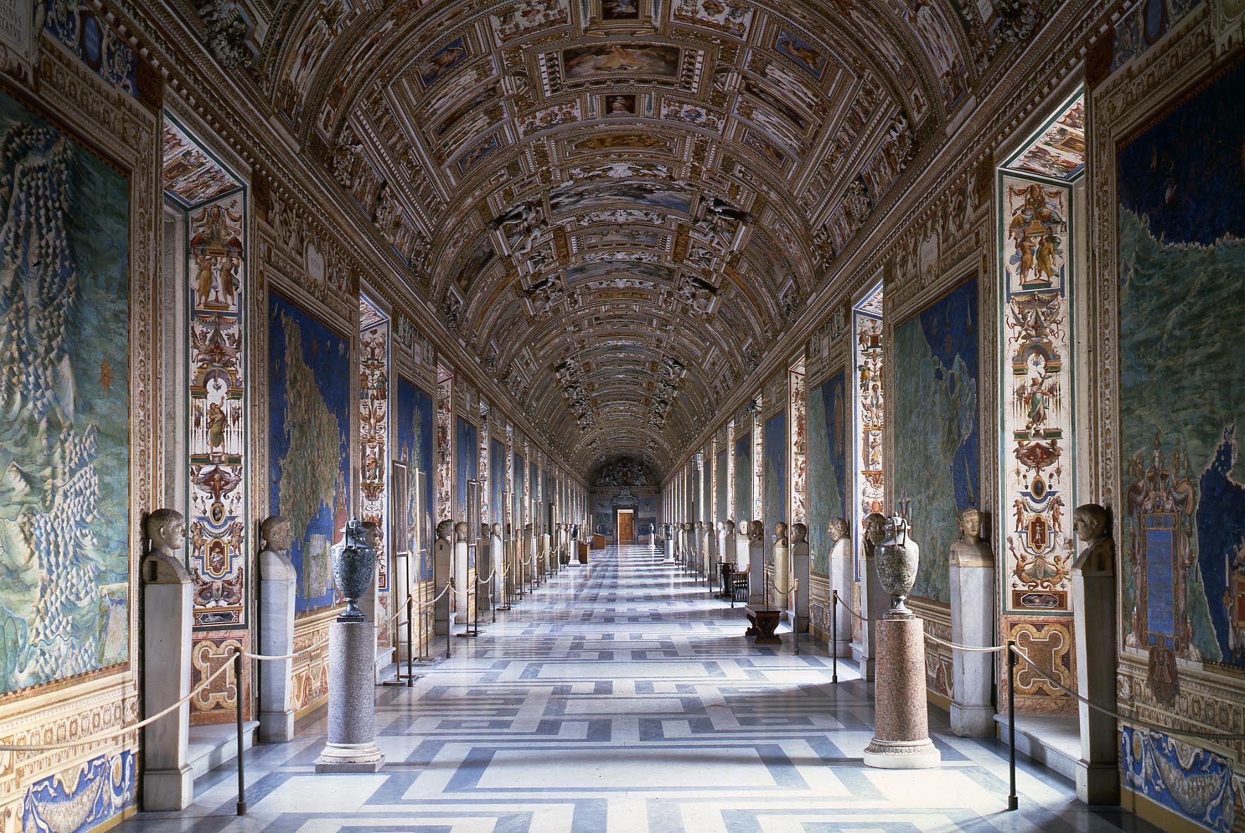
The Gallery of Maps is located in the corridor flanking the west side of the Belvedere Courtyard and was commissioned in 1580 by Pope Gregory XIII (1572-1585) as part of other artistic works commissioned by the Pope to decorate the Vatican. A series of 40 panels are filled with the topographical maps of Italy based on drawings by Dominican friar and geographer, Ignazio Danti, famed for having the most accurate maps of his time. They represent the Italian regions and papal properties at the time of Pope Gregory XIII. It took Danti three years (1580–1583) to complete the sections of the 120-meter long gallery. These frescoes constitute the largest cycle of geographical images in Europe. The panels map the entirety of the Italian peninsula in large-scale frescoes, each depicting a region as well as a perspective view of its most prominent city. With the Apennines as a partition, one side depicts the regions surrounded by the Ligurian and Tyrrhenian Seas, while the other depicts the regions surrounded by the Adriatic Sea. The maps are more like bird's-eye views with sailing ships, soldiers' tents, medieval battlements, and cypress trees dotting the hillsides. An anonymous poet, celebrating the gallery's opening, wrote:
"Each region is placed under its ruling planet and occupies an entire panel which shows the cities, castles, and villages with their streets and houses huddled together. Neither are the rivers forgotten, nor the springs, steep valleys and gentle hills, the green shade of the woods, the windswept shores, and the green expanses of the sea that truly seem to move...."
Danti, an astronomer, cosmographer, and mathematician, moved from Bologna to Rome to prepare the cartoons for the maps, in a conscious imitation of the ancient Roman custom of decorating the walls of state buildings with geographical images. With its white-capped waves, meandering streams, sailing ships, and limpid sunrises, the Gallery of the Maps is one of the most well-known in the Vatican Museums. The window cases are also richly decorated in the grotesque style made famous once again by Pinturrichio in the Borgia Apartments. There are 36 decorated window jambs, or strombi, which will also be restored along with the 40 maps.
- Venetiae Civitatis and Genua - Roberta and Howard Ahmanson
- Civitas Vetus - Bruce L. Ludwig Family
- Ancona and Melita obsidione liberatur and Classis Turcarum ad Crocyleium profligata - Dan Murphy Foundation Italia Nova - Maude and Richard Ferry in honor of John D. Ferry (Sforza)
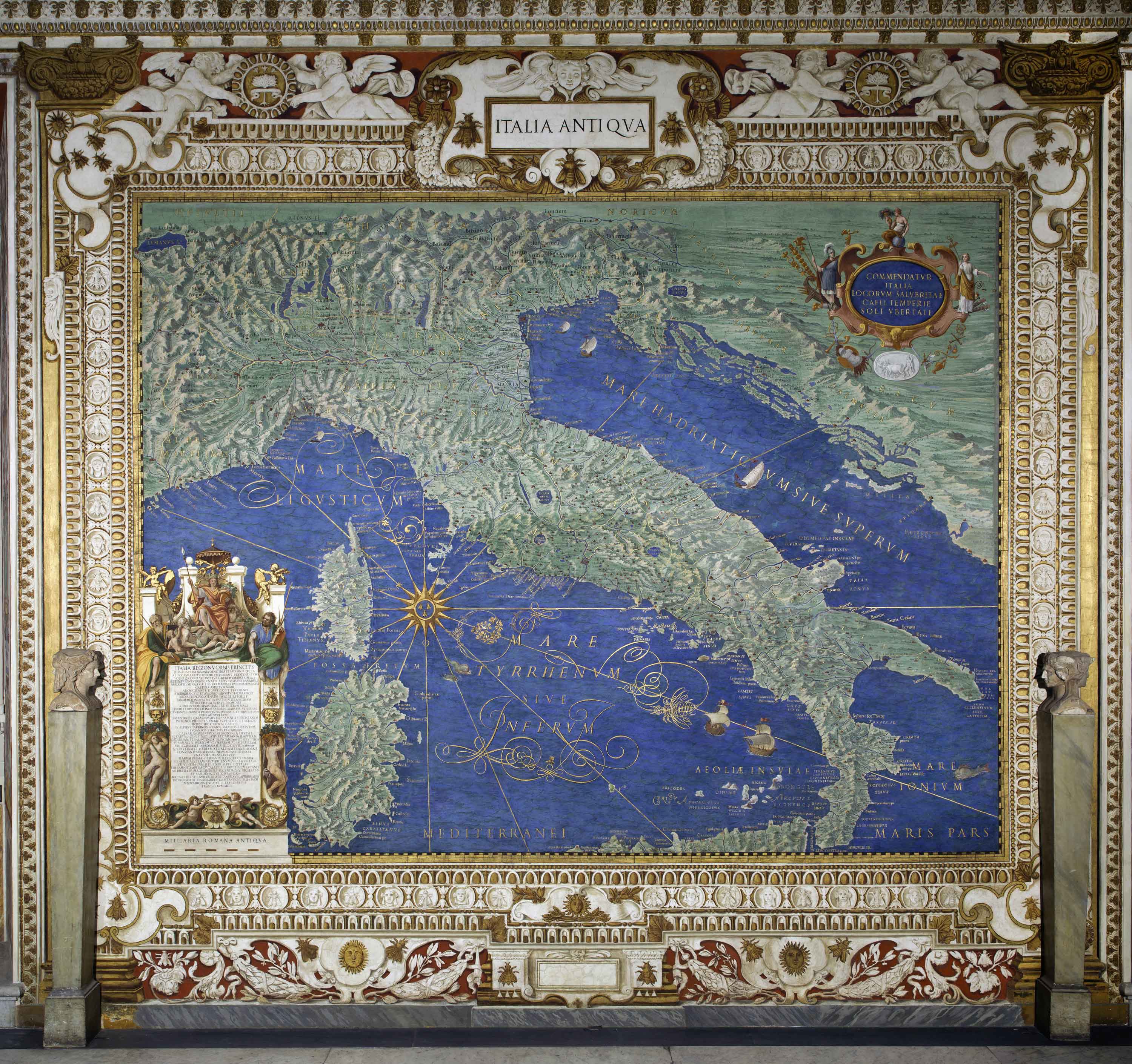
- Italia Antiqua - Janet and Michael Fourtiq
- Liguria - Marcia Wilson Hobbs in Honor of Amb. and Mrs. Wilson
- Pedemontium and Monferratus - Eileen Dibb-Haub and Robert Haub in memory of Bernard Dibb and Leora Haub
- Mediolanensis Ducatus - Virginia Milner
- Persinus ac Tifernas - McLoon Family and Knott Family
- Transpadana Venetorum Ditio - Steph and Tim Bush
- Patrimonium Sancti Petri - Roberta and Howard Ahmanson
- Umbria - Randalyn and Gregory Stanislawski
- Placentiae et Parmae Ducatus - Chris and Joe Popolo Family
- Latium et Sabina - The Turicchi Family Foundation
- Mantuae Ducatus - Therese and William Wolf
- Campania - Janet and Michael Scott Feeley
- Ferrariae Ducatus - Cynthia and Christoph Tribull
- Principatus Salerni - Debra Ann Colletti and M. Scott Cooper
- Bononiensis Ditio - Linda and Jack Del Rio Jr. and Family
- Lucania - The Blake Cesena Family
- Flaminia - The Villasenor Family
- Calabria Ulterior - The Carey Family
- Picenum - Maria and Frances Carey
- Corsica - Paul and Carol Hill Family
- Anconitanus Ager - The John and Robert Tusquellas Family
- Sardinia - The Thomas and Dorothy Leavey Foundation
- Aprutium - Anne and Kevin Watne and Family
- Sicilia - Carol and Joseph Fiorito
- Apulia - Donna and Don Kelleher in memory of Bari Kelleher
- Avenionensis Ditio et Venaisinus Comitatus - Roger and Linda Chaix
- Sallentina Hydrunti Terra - Deana Berquist and John McGraw
- Illua - Hon. and Mrs. Thad Gembacz
- Tremitae - Hortense Baffa
State of Preservation
The corridor housing the Gallery of Maps was built upon soil of a crete and tuffo base. The swampy grounds along the Vatican Hill were notoriously soft and not the best for building. All the greatest architects and engineers held it as a sign of honor to build successfully on Vatican Hill. Over time, structural problems such as cracks and fissures have developed, exasperated by the number of visitors passing through the Vatican Museums over the centuries. In combination with the climate, rain, and humidity, the 15th-16th century roof was in poor condition. The exterior wall that receives direct sunlight is particularly damaged with cracks, fissures, and general degradation of the surfaces. The rich colors and details such as the mountains, rivers, and cities were difficult to distinguish because of the thick layer of debris coating the walls. Due to the nature of the painting techniques implemented of both a fresco and a secco, different restoration processes for each have been carried out.
Restoration Procedures
- Reintegration
- Cleaning and consolidation of the pictorial surface
- Touching-up of the pictorial surface
- Cleaning and consolidation of the frame
- Completion of the frame at the bottom
- Photographic documentation
- Application of varnishes
Media
The Gallery of Geographical Maps
The Gallery of Geographical Maps - Italia Antiqua
© 2026 Patrons of the Arts
in the Vatican Museums
Vatican Museums V-00120,
Vatican City State (Europe)
+39 0669864499